When consulting with our Machu Picchu travelers before their trips, one of the most common considerations we tackle is how to hike within Machu Picchu once you arrive. You’ll need to have a general idea about which hike you want to do before you get to Machu Picchu since some of these popular trails require permits in advance. Below we describe the lay of the land, then detail each of the three hikes and how they compare.
One of the most common considerations we tackle is how to hike within Machu Picchu once you arrive.
Please note: While trekkers can still hike through the Sun Gate (Inti Punku) to access Machu Picchu, out-and-back hiking from inside the Citadel to the Sun Gate is closed until further notice to protect against the spread of COVID-19. Contact us for further details and updates on booking Machu Picchu hikes as a part of our comprehensive Machu Picchu tours.
The Lay of the Land
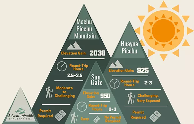
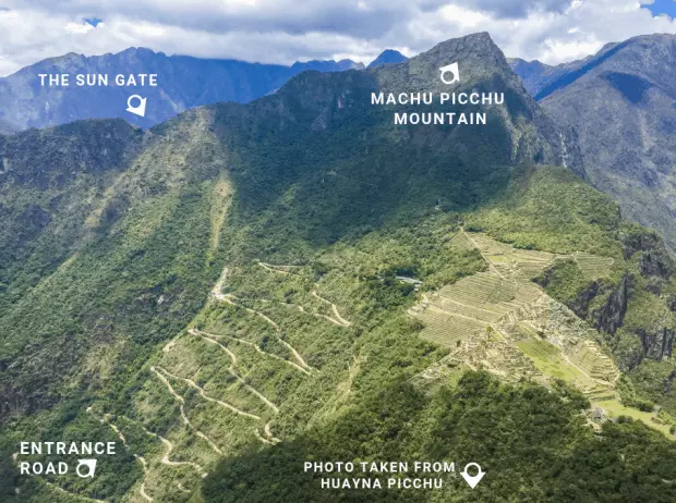
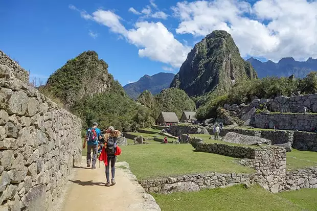
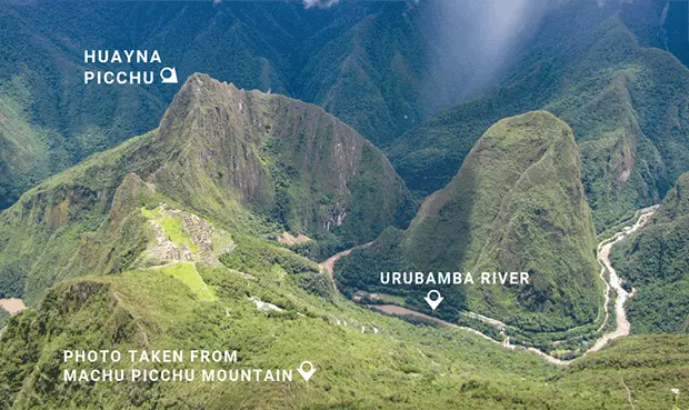
The main Citadel of Machu Picchu, where most of the iconic pre-Columbian ruins are found intact, sits at some 7,900 feet in elevation in a narrow saddle between two peaks: Machu Picchu (“Old Peak”) to the south and the iconic Huayna Picchu (“New Peak”) to the north. The Sun Gate (Inti Punku) is located on a ridge southeast of the Citadel at about the same elevation as Huayna Picchu peak. It is the historic Inca entrance as well as the modern-day entrance for hikers of the Inca Trail. All other travelers enter down in the saddle. A standard-circuit tour typically includes a three-hour walk around the main plaza in the saddle, but many travelers also opt for one of these three proper hikes up for better views.
The Huayna Picchu Hike
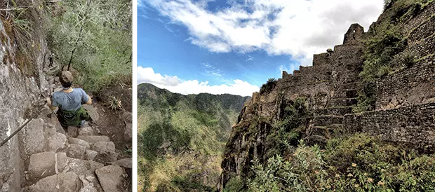
This sharp peak located at the northern edge of the Citadel requires a 45-minute to 1.5-hour hike to its 8,900-foot summit, the supposed residence of the high priest. When one looks up at Huayna Picchu it seems impossible that there’d be a walkable trail to the top. But though it is somewhat precarious and very steep, the path is doable for most adventurous able-bodied people and very worthwhile. The hardest part is the final 50 yards near the top where the stone steps are so large and steep that it is like climbing a ladder. Cables are available in places along the trail to assist. At the top you are treated to intricately laid Inca ruins on the edge of cliffs and an incredible bird’s eye view overlooking Machu Picchu and the entrance road. This is the most famous hike in the Citadel so you’ll want to secure your permit early for this popular route.
When one looks up at Huayna Picchu it seems impossible that there’d be a walkable trail to the top, but the path is doable for the adventurous.
The Machu Picchu Mountain Hike
The eponymous Machu Picchu peak is higher than Huayna Picchu, at over 10,000 feet in elevation, and therefore requires a longer journey but your reward is fewer crowds and more-pristine-feeling views since the entrance road is not in primary sight from the summit. Hikers follow a wide and well-marked trail with a fairly even grade that gets steeper and more challenging as you ascend, with some areas of exposure. Just before the summit, you’ll pass through a stone gateway and a narrow mountain ridge where gorgeous views of the Citadel and the bend of the Urubamba River around Huayna Picchu await. It is here that Inca priests once performed rituals and liturgical greetings, and when you see the view you’ll understand why.
Get a sneak peek of the Citadel and what it is like to hike Machu Picchu Mountain in this video from an AdventureSmith specialist who was there:
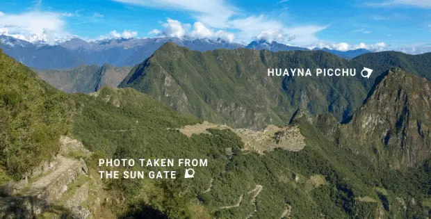
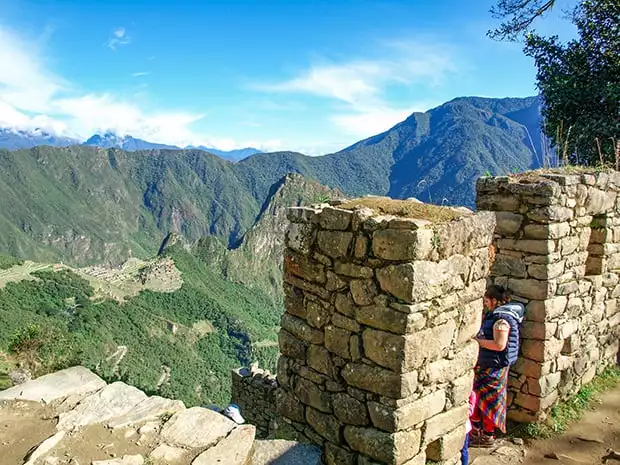
The Sun Gate Hike (Inti Punku)
If you are not comfortable hiking the steep terrain found on the other two peaks, the Sun Gate, or Inti Punku, is your best choice. Some even choose to hike this in addition to Huayna Picchu or Machu Picchu Mountain if time allows since no permit is needed. And those who trek into Machu Picchu via the Inca Trail will naturally hike one way of this trail. This gradual hike offers a similar bird’s-eye view as the others but with less arduous straight up-and-down hiking, and it can be fun to greet all the Inca Trail backpackers as they get their first glimpses of Machu Picchu. The stone path to the Sun Gate from the main saddle slopes gently up over the course of a mile or so with a few steep sections and minimal stairs, and the return is back on same path.
This less-arduous hike offers a similar bird’s-eye view, and it can be fun to greet all the Inca Trail backpackers as they cross through the Sun Gate.
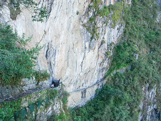
You can also detour 20 or 30 minutes to the Inca Bridge, which wraps around the other side of Machu Picchu Mountain, en route to the Sun Gate but there are some steep drop-offs and crossing the Inca Bridge is forbidden, so this detour is often skipped to save time for other highlights.
Many of the Machu Picchu trips offered by AdventureSmith Explorations include your permits and guides for these iconic hikes, and of course our expert advice on choosing your Machu Picchu hike once you’re on one of our trips. We look forward to showing you Peru and Machu Picchu!
This blog detailing Machu Picchu hikes is among AdventureSmith Explorations’ extensive collection of travel guides. Photos taken by AdventureSmith Specialists Andrew Browning, Lis Korb and Leslie Camacho, with the Machu Picchu Mountain peak view image taken by Man Bartlett via Flickr Creative Commons. For more photos and trail views see our Facebook album on the AdventureSmith Explorations’ Facebook page.
Comments will be moderated and will appear after they have been approved.